


Walking the Trail independently
Everything you need to know about exploring the Heysen Trail independently, including the different ways to walk it, how to prepare, and helpful links and resources.

How to hike the Heysen Trail independently
The 1,200 km Heysen Trail is one of Australia’s longest dedicated hiking trails, extending from Cape Jervis on the Fleurieu Peninsula to Parachilna Gorge in the Flinders Ranges. The Trail passes through some of the most scenic parts of South Australia, including national parks, state forests, native bushland and gorges, as well as vineyards, farmland, and historic towns.
You can explore parts or all of the Trail independently, or you can join guided walks run by the Friends of the Heysen Trail.
If you’re hiking the entire length of the Heysen Trail, either by through-hiking or hiking in sections, you can notify the Friends when you’ve completed your trek, and our team will send you a free completion certificate showing that you’ve hiked from Cape Jervis to Parachilna. You can also buy a cloth badge, which you can attach to your hat or backpack by contacting us.
There are three different ways to hike the Trail independently
Through-hiking the Trail
Hiking the Heysen Trail from end to end is an epic adventure. To cover the entire Trail in one trip you’ll need to be a very experienced hiker as it takes 50 to 60 walking days and parts of the Trail are very remote, with little or no phone signal.
You’ll also need to be prepared for varied weather conditions including heat and cold, wind and rain. While the Trail is well marked, you’ll need a navigation device and Personal Locator Beacon (PLB).
When you’re preparing for your hike it’s important to understand that you may need to go as long as seven days to resupply your food, which is why many people rely on food drops. There are campsites and water tanks located along the Trail, but the water tanks may be empty in dry weather and water may need to be treated.
If you’re planning a through-hiking trip the Heysen Trail E2E & Through Hiking Facebook Group is a great place to connect and exchange advice with fellow hikers. Another handy resource is the blog Trekking West by Heysen Trail Ambassador John West as it’s filled with useful information, tips and advice on hiking the Heysen Trail.
Hiking the Trail by section
There are many options for day, weekend or week-long walks along the Trail. If you’d like to hike the full Trail, but would prefer to spread your hiking over several months or even years, hiking the Trail by section is a great way to break up your walk.
Each of the 61 Trail sections takes one day to complete for experienced hikers, with most having good access to a public road and car parking, making them an easy choice for single or multi-day walks.
Use our walk selector to find a section of the Trail to walk independently or become a member and join the Friends on guided walks.
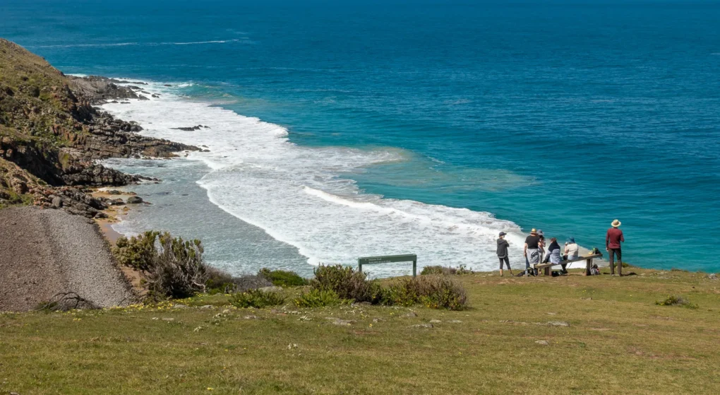
A popular section of the Heysen Trail to explore is the Wild South Coast Way (WSCW) which covers the first 75 km of the Trail. Beginning at Cape Jervis and ending at Victor Harbor, this hike has stunning scenic views and passes through Deep Creek National Park and Newland Head Conservation Park. Visit the National Parks and Wildlife Service website for more information.
Explore short walks on the Trail
You don’t need to take a weekend or even a full day to experience the Heysen Trail. There are lots of short walks to explore along the Trail, with many options suitable for walkers of all ages and fitness levels.
You can even find short walks along part of the Trail close to Adelaide and accessible by public transport.
Resources for independent hikers
These resources are a helpful guide if you plan to hike the Trail independently. Whether you’re heading off on a short day-hike or preparing for through-hiking the Trail, proper planning is key to a safe, successful and enjoyable hiking experience.
Frequently
asked questions
About the Heysen Trail
The Friends acknowledge and respect the Traditional Owners and Custodians of the lands we travel on along the Heysen Trail. These are the Ngarrindjeri, Kaurna, Peramangk, Ngadjuri, Nukunu and Adnyamathanha peoples.
The Heysen Trail is 1,200 km long and is one of Australia’s longest dedicated hiking trails.
The Trail extends from Cape Jervis on the Fleurieu Peninsula to Parachilna Gorge in the Flinders Ranges. Many people start at Cape Jervis and walk north, though some prefer to walk south from Parachilna Gorge.
Much of the Trail is closed during the Fire Danger Season which is generally from November to April. An exception to this is the Wild South Coast Way, a 75 km section of the Trail between Cape Jervis and Victor Harbor which is open all year, except on catastrophic fire danger days. Heysen Trail sections on public roads or vacant land, in forests, national parks or reserves are also open year-round except when there is a fire ban.
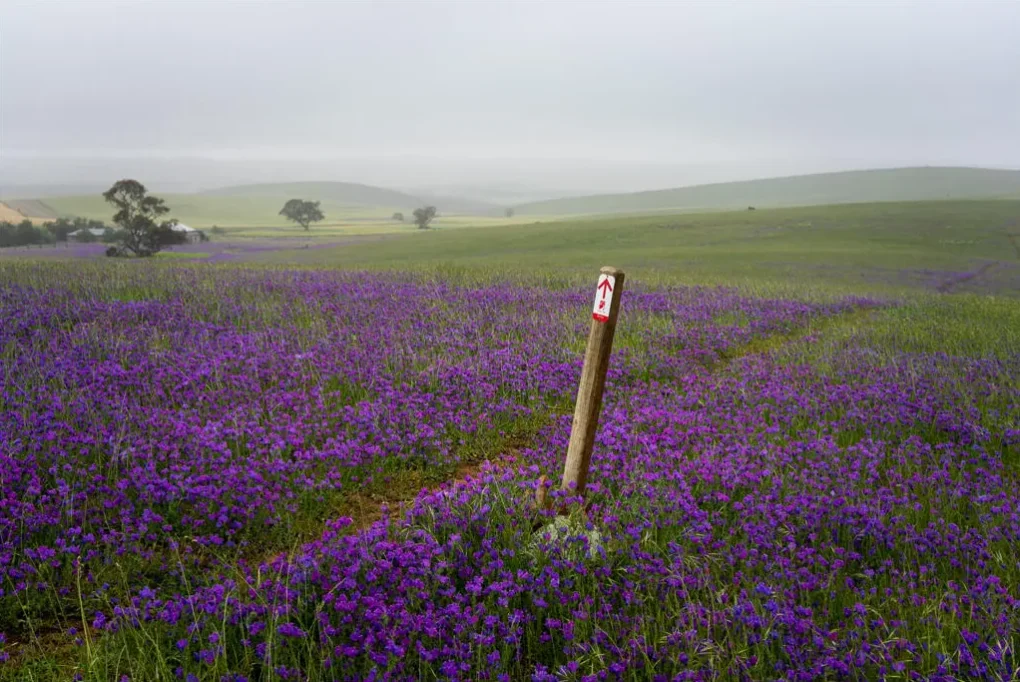
The Heysen Trail has distinctive markers to help make navigation easier. Sections that are closer to Adelaide are well marked, but for most of the Trail you should use a map. These can be purchased from our store.
From time to time we need to reroute sections of the Trail, so it’s important to check your map is up to date. We post information about Trail reroutes and closures on our website.
Walking the entire 1,200 km Trail generally takes between 50 and 60 walking days.
The Friends offer a wide range of guided walks for members including End-to-End walks for groups to walk the entire Trail. Find out more about our walk program.
There is no track beyond the Northern Trailhead at Parachilna Gorge. Occasionally very experienced wilderness hikers travel further north to Mount Babbage. This requires excellent navigation skills and equipment as there are very few roads or vehicle tracks, no mobile phone coverage, and hikers may travel for a week or more without seeing anyone. Water is very scarce, so water drops may be needed, and much of the land is privately owned which means hikers need to get permission from property owners.
Safety on the Heysen Trail
You’ll need to be well prepared for hikes along the Trail especially as you travel further away from Adelaide. Find out more about staying safe on the Trail.
There are easy sections of the Trail, but many parts are graded within classes 4-5 of the Australian Walking Tracks classification which means you’ll need to have moderate to high-level walking skills.
Much of the Heysen Trail is in very dry country. Water may be difficult to find and, depending on where you are, the nearest town may be up to 80 km away. There are around 75 water tanks along the Trail, but these may be empty in dry weather and the water may need to be treated. Always carry enough water for your needs and treat tank water before drinking.
Mobile phone coverage is very limited along the more remote parts of the Trail. Mobile phone service providers often provide network coverage maps.
Most of the larger regional centres have a Telstra payphone. Standard national and mobile calls are free of charge from all Telstra payphones. You can use a Telstra Phonecard or a third-party calling card to make international calls or calls to other charged destinations. Some payphones are Wi-Fi hotspots. Find out more about payphones.
You should always carry a first aid kit and leave details of your walking plan with someone who can contact the police if they are concerned about your safety. Try contacting Emergency Services if you need support and stay as close as possible to the track while you wait for help.
If you get lost, try to retrace your steps until you find a trail marker or recognise a feature. You should use a GPS unit for the more remote sections of the Trail.
Accommodation and transport
There are huts, shelters and campsites along the Trail and you can only camp in these areas. You can find the location of these using our Interactive Maps and selecting the Accommodation layer.
Facilities vary along the Trail but most campsites are very basic, so you should aim to be totally self-sufficient. The huts provided by the Friends can’t be booked so it’s best to carry a tent in case they’re full. Find out more about campsites using our Interactive Maps.
The Heysen Trail passes through or near many towns with excellent overnight accommodation including bed and breakfasts, farm stays, hotels, motels and caravan parks. As you travel further north along the Trail there are fewer towns and accommodation options. Find out more about accommodation.
Car parking is available at many points along the Trail, generally in towns, public car parks or on the roadside. Some sections of the Trail are accessible by bus or private transport operators. Find out more about transport.
Trail access
The Trail is maintained by the Friends of the Heysen Trail with the assistance from a number of walking clubs. We welcome feedback about Trail conditions. Contact us.
Only guide dogs are allowed on the parts of the Trail in National Parks, native forest reserves or private property. You can take your dog where the Trail goes along public roads and in ForestrySA forests. Find out more from the ForestrySA website.
The Heysen Trail is intended for walkers, however parts of the Trail pass through ForestrySA sites and along roads where horses or bikes may be allowed. Other trails suitable for cyclists or horses include the Mawson Trail and Kidman Trail.